Snow has been falling overnight, but it hasn’t been reaching the ground, due to dry air. That will change later this morning, as the atmosphere moistens. Expect areas of light rain and snow to develop between 5 to 7 a.m. There could be patchy freezing rain and/or sleet in Mifflin and Juniata Counties, leading to a glaze of ice. A Winter Weather Advisory is in effect for Mifflin and Juniata Counties until 9 a.m. Low impacts are expected for the rest of the area, as temperatures hover between 32 to 35 degrees. Precipitation will taper between 9 to 11 a.m. from west to east. The rest of the day will feature mostly cloudy skies and highs slowly rising to near 40 degrees. Winds will be light.Tonight, the sky will gradually clear, and temperatures will hold steady in the upper 30s. It will turn windy, as low pressure moves off the East Coast, and high pressure builds in from the Great Lakes. If you’re traveling or doing any last-minute shopping Wednesday, the forecast looks great. Expect mostly sunny skies and highs in the mid-40s. It will be windy early, then winds will diminish by afternoon. Quiet weather is in store for Christmas Eve services Wednesday evening, then clouds increase late.Christmas will feature mainly cloudy skies and isolated rain showers. Highs will reach 44 degrees, and winds will be light.IMPACT FRIDAY: WIDESPREAD WINTRY MIX POSSIBLEA stronger area of low pressure will pass to our south on Friday, while high pressure presses in from the northeast. This will lead to a wintry mix developing by afternoon. Highs will be chilly, in the low 30s, and the wintry mix could last through early Saturday morning. The rest of Saturday looks dry and seasonable under mostly cloudy skies. A chance of rain returns Sunday, with highs in the low-to-mid 40s.Colder air arrives Monday, along with blustery conditions. The last few days of December look cold, with highs in the low 30s and lows near 20 degrees. Wind chills will range from the teens to 20s.
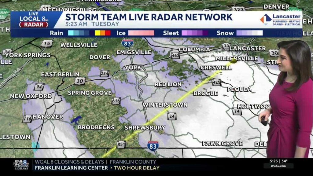
Snow has been falling overnight, but it hasn’t been reaching the ground, due to dry air. That will change later this morning, as the atmosphere moistens.
Expect areas of light rain and snow to develop between 5 to 7 a.m. There could be patchy freezing rain and/or sleet in Mifflin and Juniata Counties, leading to a glaze of ice. A Winter Weather Advisory is in effect for Mifflin and Juniata Counties until 9 a.m.
Low impacts are expected for the rest of the area, as temperatures hover between 32 to 35 degrees. Precipitation will taper between 9 to 11 a.m. from west to east.
The rest of the day will feature mostly cloudy skies and highs slowly rising to near 40 degrees. Winds will be light.
Tonight, the sky will gradually clear, and temperatures will hold steady in the upper 30s. It will turn windy, as low pressure moves off the East Coast, and high pressure builds in from the Great Lakes.
If you’re traveling or doing any last-minute shopping Wednesday, the forecast looks great. Expect mostly sunny skies and highs in the mid-40s. It will be windy early, then winds will diminish by afternoon. Quiet weather is in store for Christmas Eve services Wednesday evening, then clouds increase late.
Christmas will feature mainly cloudy skies and isolated rain showers. Highs will reach 44 degrees, and winds will be light.
IMPACT FRIDAY: WIDESPREAD WINTRY MIX POSSIBLE
A stronger area of low pressure will pass to our south on Friday, while high pressure presses in from the northeast. This will lead to a wintry mix developing by afternoon. Highs will be chilly, in the low 30s, and the wintry mix could last through early Saturday morning.
The rest of Saturday looks dry and seasonable under mostly cloudy skies. A chance of rain returns Sunday, with highs in the low-to-mid 40s.
Colder air arrives Monday, along with blustery conditions. The last few days of December look cold, with highs in the low 30s and lows near 20 degrees. Wind chills will range from the teens to 20s.
Source link


