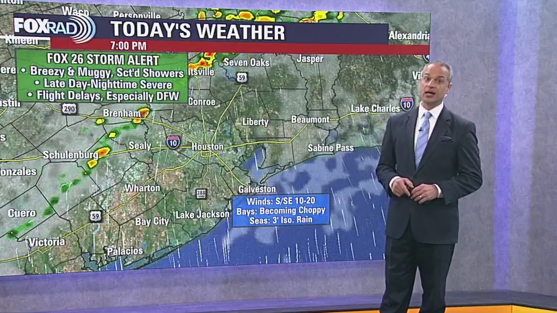
HOUSTON – Expect breezy and muggy weather this Monday afternoon. A FOX 26 Storm Alert is in effect for tonight and very early Tuesday.
Tornado Warning & Watch
The National Weather Service has issued tornado watch for several counties near the Houston-area, including Austin, Brazos, Burleson, Fort Bend, Grimes, Harris, Houston, Liberty, Madison, Montgomery, Polk, San Jacinto, Trinity, Walker, Waller, and Washington.
Several cities are also included under this watch including Bellville, Brenham, Brookshire, Bryan, Caldwell, Cleveland, Coldspring, College Station, Conroe, Corrigan, Crockett, Dayton, First Colony, Groveton, Hempstead, Houston, Huntsville, Liberty, Livingston, Madisonville, Mission Bend, Missouri City, Navasota, Pecan Grove, Prairie View, Rosenberg, Sealy, Shepherd, Somerville, Sugar Land, The Woodlands, Trinity, and Waller.
The watch is in effect until 7 p.m.
A tornado warning has been issued by the National Weather Service for parts of Austin and Waller County until noon. A severe thunderstorm capable of producing a tornado was located near San Felipe, or near Sealy, moving northeast at 20 mph, according to the NWS.

Severe weather threat
A cold front approaches today, helping spark showers and thunderstorms by mid to late afternoon. The strongest storms are expected mainly north of I-10 and west of I-45, where damaging winds, hail, and an isolated tornado are possible. Storms gradually shift south and weaken late tonight and early Tuesday as the boundary settles toward the coast.
Houston weather: Muggy, isolated showers for Monday
This Monday afternoon, expect the weather to be breezy and muggy. There may be some isolated showers rolling through before we see storms this evening. A FOX 26 Storm Alert is in effect for tonight and very early Tuesday.
You should expect the National Weather Service to issue either a severe thunderstorm watch or a tornado watch sometime late today – this means conditions are favorable for severe storms during the watch time period.
Travel Delays Today

Periods of heavy rain and gusty winds stopped air travel out of North Texas this morning while Bush and Hobby airports could be impacted as storms move through during this evening and tonight.
Travelers should plan for possible delays, especially after midday through tonight, plus ripple effects due to morning rain elsewhere in Texas.

Thanksgiving Outlook
A stronger front moves on Tuesday night into Wednesday, bringing cooler, drier air into the region.
Thanksgiving Day is expected to be pleasant and festive, with lower humidity and cool temperatures. Expect a chilly morning, then a sunny and cool day. Rain could return by late Saturday and Sunday.
The Source: Your Gulf Coast Weather Authority
Source link


